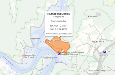
Adding NSW Hazard Reduction Burns to the Map

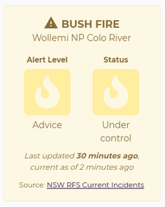
We are well and truly into hazard reduction season now. After planning out a walk, travelling to the start only to discover a prescribed burn taking place I knew I needed to improve BeyondTracks. For a long time we’ve shown active fires from NSW RFS, but this didn’t show areas planned for hazard reduction before the burn started. So from today we show planned hazard reduction burns for NSW on the map.

Posted

Inaturalist Integration

Recently I’ve become more interested in the flora and fauna seen out bushwalking and the reason for that is iNaturalist. iNaturalist is a social media platform where anyone can submit their wildlife sightings with a focus on identifying the species observed. Anyone can submit an identification (known on the site as an ID) of what they think the species in your observation is, and vice versa you can help identify others observations.

Posted

Designing an Australian Bushwalking Map - Part 1

In March 2019 we quietly launched the new BeyondTracks map and I wanted to share the thinking and design principles behind it. The map was designed with the primary goal to be useful for bushwalking in Australia, both planning before you set out and on the ground in the country. With that in mind, together with my experiences with maps I wanted to ensure the following criteria were met. 1. Show enough detail This is by far my biggest frustration with most other maps I’ve used so far.

Posted

Improving our Elevation Profiles

One of the core principals I’ve had from the start is that as much as possible the walk pages should be automatically generated. The opposite of that is of course writing something like a Wordpress blog post for each walk, manually calculating and entering distance, climb etc (these are all calculated), manually assigning photos (we use geotagging to automatically assign them), manually tagging the walk as coastal, scenic, etc (we determine this with OSM data).

Posted

Node Worker Threads With Async Parallel

worker_threads is a new feature of Node 11, allowing multithreaded operations with Node. Especially useful for CPU intensive workloads where you wish to make use of a multicore machine. async is a module for Node which helps provide a framework for various async operations in Node. It can provide speedups for IO (disk, network) intensive workloads, but since it still only runs on a single thread doesn’t help much for CPU intensive workloads.

Posted

Speeding Up GitLab CI With Docker

We use GitLab CI extensively to build and deploy BeyondTracks. However we have some heavy dependencies, which we used to build and install every time our CI process ran. This added an extra 5 minutes at the start of every build, which is just wasteful. To speed things up we wanted to follow best practice by installing our dependencies into a Docker image and reused that in our build. It was important that this Docker image had a well document build process, which didn’t depend on any local configuration, meaning it needed to be built by GitLab CI.

Posted

Mapbox GL JS Popups with Vue

BeyondTracks uses Mapbox GL JS and Vue, however to quote from github.com/phegman/vue-mapbox-gl: Popups can be a little tricky if you are trying to use Vue directives inside the popup content. This is because the popups are added to the DOM by Mapbox and not compiled by Vue. We use Vue, we also use Mapbox GL JS Popups on our maps to show walk summaries, bushfire alerts and beach conditions.

Posted

Sun Times

Sunrise and sunset times are important to know when walking, how early can you start, when do you need to finish by within daylight? What time does the sky become golden for stunning sunset photos? To show the current sun times for each walk on BeyondTracks we use: suncalc tz-lookup Luxon suncalc will, given a date and latitude/longitude return a set of sun times, we choose the show the sunrise, sunset, dawn and golden times.

Posted

Beach Conditions

A lot of walks on BeyondTracks go past a beach, and on a hot day it’s nice to go for a dip along the walk. The NSW Department of Environment publishes information about beach conditions, similar to how we work with Fire Incidents from the NSW Rural Fire Service, we pull in beach conditions data and show this on the maps on BeyondTracks. Beach conditions map popup We open sourced our Node module which makes the Beachwatch GeoRSS feeds more developer friendly, in particular to:

Posted

Fire Incidents

It’s not a good idea to go walking when there’s a bush fire nearby, hence it’s important for us to include bush fire information on BeyondTracks. We do this by showing all fire incidents on the map, and then again alerts for fire incidents nearby each walk. At the moment we only do this for NSW, but in the future we hope to expand it Australia wide. BeyondTracks map showing fire incidents BeyondTracks fire incident alert Source Data Tim Berners-Lee suggested a 5-star rating system for open data:

Posted